Echo-3 turns an iPhone scan into a space you can revisit
SpAItial's Echo-3 reconstructs phone captures as explorable 3D environments. Understand generated gaps, iPhone requirements, commercial rights, and a useful first pilot.
A photograph can show a room's best angle. It is much worse at answering a colleague's next question: what is behind that table, and how does the doorway connect to the corridor?
SpAItial introduced Echo-3 and its companion iPhone app on October 27, 2026, with a workflow for turning phone captures into explorable 3D environments. The company develops spatial models that combine reconstruction and generation. Echo-3 extends that work toward recreating real places from a more detailed capture, following Echo-2's image-based world generation. SpAItial launch announcement
For readers considering property presentations, remote facilities discussions, or simulation inputs, the appeal is a shared place to look around. The important boundary is equally concrete: Echo-3 completes regions the camera did not see. This guide explains what that means, how the app's plans and capture requirements work, and how to build a first trial that distinguishes a convincing scene from verified evidence.
 AccuCities’ stereophotogrammetry model of London, published in 2022; independently captured-space context, not an Echo-3 reconstruction. Image: AccuCities, CC BY-SA 4.0; resized with margins. Image source · License and image notes. Official product reference.

A complete-looking room can contain generated surfaces
SpAItial says Echo-3 reconstructs captured appearance and real-world-scale geometry, then fills missing regions to fit the surrounding scene. That completion is central to the product: a quick walk through a room will inevitably leave some surfaces unseen. The October 27 announcement describes the result as metric geometry, but it does not establish an independently measured error tolerance for your room. Echo-3 announcement
The distinction becomes obvious when a sofa hides a patch of floor. A model can create a plausible continuation of the visible flooring and make navigation feel coherent. That is useful for a presentation. It does not prove that the concealed floor has the same material, is undamaged, or even lies at the assumed height.
Our take: the right mental model is a spatial notebook with a careful distinction between what was observed and what was completed. A beautiful reconstruction helps people understand relationships. It becomes more useful when the project also retains the original capture, the date, and a short list of facts checked on site.
This is especially important when a scene travels beyond its creator. A colleague who never visited the building may assume every surface came from direct observation. A caption explaining generated completion can prevent that misunderstanding before the model becomes a reference in a proposal, maintenance ticket, or training exercise.
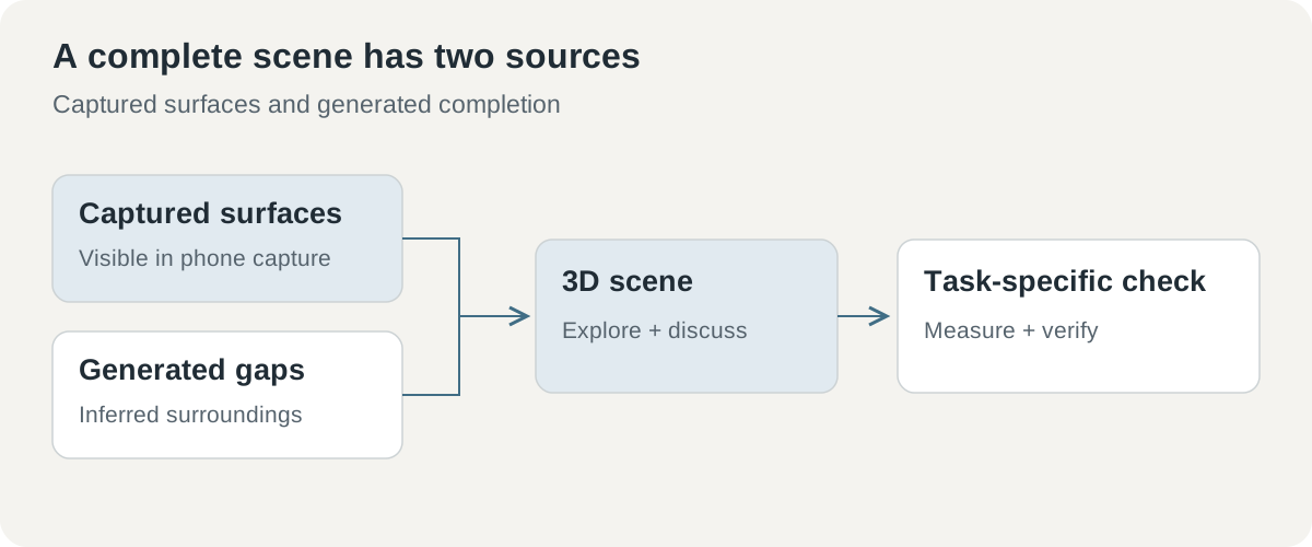 Echo-3 combines captured information with generated completion. Decisions about dimensions, condition, or safety still need the evidence appropriate to that decision.
An iPhone is the capture device; generation happens in the cloud
The developer's App Store description, checked November 2, specifies iOS 18 or later, a SpAItial account, internet access, and enough credits for generation. Captures are saved on the phone before upload. The selected scan is then processed in the cloud, and the finished private world opens in a viewer. SpAItial App Store listing
That sequence gives a team two moments to make a decision. First, decide whether the room is appropriate to capture at all. Then review the recorded material before sending it for processing. For an office, that could mean clearing customer documents from a desk and choosing a time when screens and people are absent from the intended route.
The device distinction matters too. Supported non-LiDAR iPhones can capture, while live coverage guidance and dense point-cloud previews belong to LiDAR-equipped Pro models. A person following an online demonstration should therefore check whether its guidance views match their device. The capture workflow and the availability of every preview feature are separate questions. Developer's iPhone requirements
The launch article describes Android as coming soon and directs enterprise API users to contact SpAItial. An organization planning around Android devices or embedding reconstruction in its own application should establish that delivery path before organizing a field program. The publicly described iPhone workflow is the concrete starting point today. SpAItial getting-started information
Credits measure capture length, not the size of the story
The App Store description lists 300 credits per recorded scan minute, with a 900-credit minimum. Standard includes 7,500 monthly credits for noncommercial work, while Pro includes 15,000 and commercial rights. Those correspond to up to 25 and 50 scan minutes before the minimum and individual capture choices affect usage. Check the current local purchase screen and terms before subscribing; a free download is not a grant of free commercial generation. SpAItial plan description, checked November 2, 2026
The minimum changes how small experiments should be budgeted. A one-minute capture and a three-minute capture both reach 900 credits under the stated formula. A four-minute capture requires 1,200. These are calculations from the published credit rule, rather than reports of completed transactions.
| Illustrative recorded length | Credits from the listed rule | What to consider |
|---|---|---|
| 1 minute | 900 minimum | Very short captures still meet the minimum |
| 3 minutes | 900 | Enough route planning can improve what those credits cover |
| 4 minutes | 1,200 | More recorded time increases the generation allocation |
The economic question is how many useful spaces the team can produce, not how many minutes it can record. A poorly covered room can require another generation. A long scan can consume more credits while still missing the critical equipment label. Plan the views around the decision someone needs to make later.
Commercial rights also belong in the project brief. A personal room experiment and a paid real-estate presentation have different purposes even if the captures look identical. Keep the chosen plan and applicable usage terms with the project so the person publishing the final material does not have to reconstruct that decision afterward.
A property presentation benefits from relationships between rooms
Imagine a property manager preparing a remote viewing. This is an illustrative workflow, not a report of a tested customer deployment. Conventional photos can show finishes clearly, while a navigable reconstruction helps a prospective visitor understand the route from the entrance to the living space. The practical gain is less back-and-forth about orientation.
The presentation should still identify the capture date and distinguish measurements from visualization. If a buyer asks whether a particular sofa fits through the door, confirm the actual clearance with an appropriate measurement. The 3D scene can help everyone point to the same doorway. It should not turn a plausible visual impression into an unsupported guarantee.
A useful deliverable combines the reconstructed tour with a short annotated plan and selected original photos. Those materials answer different questions. The tour carries spatial relationships, the plan names locations, and the photos preserve the observed detail at important points. Keeping them together makes the presentation easier to trust and easier to update when the property changes.
For furnished spaces, prepare a route around the objects that matter. A viewer may want to look behind a dining table or see how a stair landing connects to the next floor. If these relationships are important, capture them deliberately rather than expecting completion to reconstruct the hidden layout from a single passing view.
A facilities meeting needs a common place to point
A second illustrative use is planning maintenance with an off-site specialist. A technician can capture an equipment room so colleagues understand where components sit relative to the entrance, work area, and neighboring machines. That shared context can make a discussion more efficient than sending a folder of unconnected photographs.
The close-up evidence still matters. A generated reconstruction of a label is a poor substitute for a legible source image of the serial number. A proposed route for moving replacement equipment requires confirmed dimensions and local constraints. Use the scene to organize the conversation, then attach the evidence required for the actual work order.
A third illustrative use is preparing an environment for simulation or scene editing. SpAItial explicitly names simulation inputs and AI-agent scene understanding among enterprise applications. Echo-3 enterprise description, October 27, 2026 For a pilot, choose a task with a visible acceptance criterion: can the downstream tool use the intended space and preserve the features that matter?
That question is more practical than asking whether the reconstruction is “realistic.” A scene can be attractive but unsuitable for a task that depends on a hidden passage, precise collision geometry, or surface friction. Define the required properties before selecting the export and integration path with the vendor.
Polycam, KIRI Engine, and Scaniverse belong in a matched trial
SpAItial's launch article includes its own comparison with Polycam, KIRI Engine, and Niantic Scaniverse, using similar capture paths. The company emphasizes cleaner-looking surfaces in that demonstration. It is a vendor-selected comparison, rather than an independent ranking across all room types, devices, or output requirements. Official Echo-3 comparison
If you are choosing between those tools, define the same job for each. A property marketer might prioritize visual clarity and sharing. A designer may care more about the downstream asset format. A facilities team may care about which observed details can be traced back to the source capture. A single aesthetic score hides those differences.
| Criterion for a matched trial | Concrete question |
|---|---|
| Capture effort | Can the same operator cover the same room with the available phone? |
| Geometry | How do selected real measurements compare with the usable output? |
| Missing coverage | What happens to surfaces the route never recorded? |
| Delivery | Does the result fit the intended viewer, license, and downstream tool? |
Retain failures and regeneration attempts in the comparison. If one application produces a usable result only after three scans, that effort belongs in the evaluation. Conversely, a visually plain output may be the better choice when it preserves the exact property the downstream task requires. Start with the acceptance criterion and work backward to the tool.
Include the person who will actually receive the scene in that trial. An experienced operator may navigate around a missing view without noticing, while a remote colleague becomes confused at the same point. Ask that colleague to locate a room, identify the equipment under discussion, and explain which facts they would still need confirmed. Their questions reveal whether the deliverable communicates enough context. A capture is successful when another person can use it for the agreed task, rather than when its creator enjoys exploring it.
Begin with one room and a capture plan
SpAItial's September 27 capture guide recommends steady motion, consistent lighting, multiple viewpoints, and deliberate coverage of floors, ceilings, and corners. It also advises moving closer to important details and preparing connected rooms before recording. These are concrete actions a first-time operator can take before spending generation credits. Official capture guide
- Choose an authorized, uncomplicated space. Start with one room where you can control access and remove sensitive material. Decide what the reconstruction needs to show.
- Check the phone and plan. Confirm iOS compatibility, whether your device offers LiDAR guidance, and whether the selected usage rights fit the intended output.
- Prepare the route. Improve lighting, open connecting doors in advance, and identify mirrors and difficult surfaces. Plan views of the floor, ceiling, and hidden sides of furniture.
- Capture slowly from several positions. Include the relationships between rooms or objects, then move closer to the details your use case needs.
- Review before upload. Inspect coverage and unintended content. Keep original reference photos and any independently measured dimensions with the project.
- Evaluate the finished scene against the task. Check selected locations and distances, note generated gaps, and record whether another pass would materially improve the result.
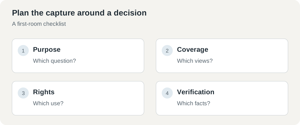 A useful first trial answers four questions before publication: what is the scene for, what was captured, what rights apply, and which facts need verification?
The room should become easier to discuss
Echo-3's most promising contribution is making a real place easier to revisit together. A navigable space can preserve relationships that a scattered photo collection leaves readers to infer. The right companion is a clear record of capture, completion, and task-specific checks.
Expect progress to be judged on more than visual smoothness. Better explanations of coverage, dependable downstream integration, and manageable generation costs will determine how often people can use these scenes in ordinary work. The question to take into a pilot is simple: does this reconstruction help the next person make a better-informed decision about the actual place?
Sources
- SpAItial: Echo-3 and the companion app, October 27, 2026.
- SpAItial iPhone app and developer plan description, checked November 2, 2026.
- SpAItial capture guide, September 27, 2026. Examples and credit arithmetic above are illustrative; geometry accuracy and generated output were not independently measured here.
Keep the capture connected to its context
Telli.sh is one option for retaining authorized source material, site notes, and decisions made during a project. Create a note workspace.